| The city of Lisbon is a place
at the centre and at the periphery, a connecting place and cultural meeting point –
just as it is a city with many diverse styles of architecture. 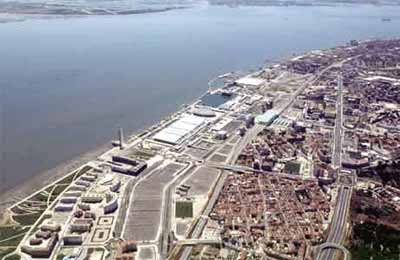 It is a unique geographically diverse place of sloping hills and
valleys, with buildings of blue limestone, plasterwork and frames in blended colours,
pavements in white stone and basalt, a breezy and windy place with its waterfront forming
the emblematic countenance of a point of arrival. It is a unique geographically diverse place of sloping hills and
valleys, with buildings of blue limestone, plasterwork and frames in blended colours,
pavements in white stone and basalt, a breezy and windy place with its waterfront forming
the emblematic countenance of a point of arrival.
It is a place of metamorphosis, reinventing
itself and interweaving a succession of diverse urban styles; a city with an expansive
culture, but one which is paradoxically both inward-looking and outward-looking.
| © Parque
EXPO'98 S.A. - Bruno Portela |
In urbanistic terms the
city is highly complex and sensitive – it has undergone a process of cultural
sedimentation and articulation with its surroundings, with little in the way of structural
urbanistic initiative – it is a fragile city, with conflicts of scale due to the
rapid growth of its recent transformation, possessing little public space.
The structure of the city
of Lisbon, established on the hill of the Castle, begins with the model of the Roman
cities – organisation by centres, well defined functionally and spatially, where the
castle (hill), the civic centre (the slope), the port (the riverfront), are laid out with
the dimension of a city in the network of Roman towns, all interconnected by the network
of roads.
Successively, the Arab
occupation, the Christian reconquest, the installation of the capital of the kingdom, the
periods of the discoveries to D. Joăo V, all construct a city where multiple cultures and
urban models coexist.
With the catastrophe of
1755 – earthquake, seaquake, fire – came the city’s first structuring
initiative which not only brought about the design of a new urban model and a new style of
architecture – including the methods of construction, the modulation, rationalisation
and standardisation of materials – but also it would promote a major transformation
in urban production and management.
Later, public areas were
added on – boulevards and walkways – and with the development of transportation
– coinciding with industrial growth – the city gained a whole new dimension. The
railway and the tram came along, the road system spread out with new avenues following
simple geometrical models which gave way to the organised expansion of the city and the
construction of new neighbourhoods.
The urban model then
proposed, associated with the demarcation of the urban perimeter by a ring-road –
with the river remaining as a natural barrier to growth – created hierarchies within
the city in relation to its centre, creating the future peripheries and bringing
speculation concerning the value of the land.
In 1900 the railway belt
marked out the periphery of the constructed city – the Alcântara Valley, Sete Rios,
Entre-Campos, Xabregas. The population was about 300,000 inhabitants and the urban model
relied upon the city as a harmonically structured area.
The New State idealised the city as a whole
and its first urbanisation plan (1948, E. de Groer) structured it according to a pattern
of radials and circles – channels of road traffic – which dissected the city.
Land is expropriated and large reserves of
urban terrain are constituted which will be used in the construction of the Monsanto
Forest Park, the Airport, neighbourhoods of social housing, Public Works and the
Portuguese World Exposition.
The increase in individual
transport to the detriment of collective transportation and the rapid concentration of the
population in the city of Lisbon ( 800,000 inhabitants in 1960) changed the consolidated
growth of the city. The road network channels profoundly transformed its physiognomy
– they altered the time and scale of a city with a complex urban topography and
layout – they fragmented it and destroyed the unity that had formed over the
centuries.
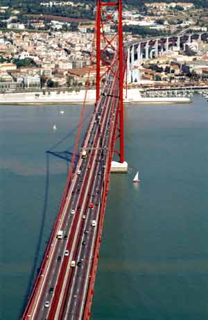
The Bridge over the river
Tagus, between Alcântara and Almada (1966), did nothing to improve the urban organisation
of the city of Lisbon. It was thought of as a component of the national network of
highways which would link up the motorways of Cascais, Sintra, the West and North and as
such it dissects and congests Lisbon.
When the city stabilised at 850,000
inhabitants within the limits of its urban perimeter (before the commencement of its
regression with the Metropolitan Area of Lisbon reaching 2,500,000 inhabitants) it was a
city structured by roadways and specialised, mono-functional areas.
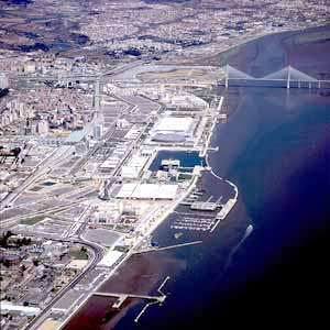
| © Parque
EXPO'98 S.A. - Bruno Portela |
When all of its land became occupied due to
a process of population migration, decentralisation and dispersal of power, the city then
began a process of recovery, redevelopment, regeneration and revitalisation of its terrain
– recycling and re-using the city.
 It is within this
context that the idea arose to launch a major catalytic project of renewal of the city
which would mobilise the means and generate the synergies to bring about the effective
modernisation of Lisbon. It is within this
context that the idea arose to launch a major catalytic project of renewal of the city
which would mobilise the means and generate the synergies to bring about the effective
modernisation of Lisbon.
The urbanistic and environmental components
constitute determining factors in the redevelopment of the Intervention Zone of the EXPO
98, with other relevant aspects being the climate, hydric resources, geology, the
reduction in energy consumption associated with urban comfort, transportation, buildings
and infrastructures – where the centralised distribution of heating and refrigeration
is included – the urban design associated with the conception of public space and
green areas, the system of viewpoints, diversity and density of use, cultural and
architectural evidence of urban art and technological innovation, the uniqueness and
sensitivity of the place itself.
| © Parque
EXPO'98 S.A. - Abílio Leităo |
|