1.
GENERAL FRAMEWORK
The Regional Plan of
Territorial Organisation of the Metropolitan Area of Lisbon, PROTAML, proposed the
recovery of the eastern margin of the city of Lisbon, which in 1993 constituted an
abandoned and degraded periphery, occupied by insalubrious and dangerous installations.
From the architectonic and
urbanistic detailed studies provided in the Competition for Ideas for the Renewal of the
Riverfront Area, promoted by the Association of Portuguese Architects in 1988, and in the
VALIS in 1990, came the study of the location of the Expo 98 in 1991, the Preliminary
Master Plan of which, prepared by Architect Carlos Duarte and José Lamas, ensured the
realisation of this event in Lisbon, in competition with other cities around the world.
At the end of 1992, with
the corridor for the new road crossing of the River Tagus established between Sacavém and
Montijo, the Vasco da Gama Bridge, and based on the Preliminary Master Plan, the
Architects Graça Dias and Egas Vieira prepared the Study for the Urban Design Model for
the Area Surrounding the EXPO’98, the objective of which was to establish an idea of
urban design and evaluate the capacity for construction of the land.
Once the decision to hold
the 1998 International Exposition in Lisbon was confirmed, later the World Exposition,
EXPO’98, the structure which would promote it, the Parque Expo’98, S.A., PE 98,
S.A., was instituted and was granted specific attributes and powers in terms of the
organisation of the Intervention Zone, IZ.
By mid 1993, based on the
Preliminary Urbanisation Study, prepared under the direction of Architect Nuno Portas
– which constituted a strategic document of urbanistic management and already
anticipated a proposal for the design of public space capable of bringing together the
projects to be developed – the Competition for Ideas for the EXPO’98 Site was
launched, in an area confined to 25 hectares, not with the purpose of selecting the
proposal for the definitive plan for the site, but to generate ideas for its organisation.
The proposals presented by
the candidates were mostly limited to the space of the Exposition Site; however, some also
referred to the framework of the IZ, respecting it or altering it. Of the five proposals
which received prizes, two were withheld: those of Architect Norman Foster and Architect
Manuel Vicente, both with a strong symbolic impact and assuming the "ephemeral"
as an urban language.
*IN "EXPO 98 ARCHITECTURE"
publisher BLAU, 1998 – Luís Vassalo Rosa. The Plan and Project for the Public Space
of the Site constituted a text which was appended in 1999.
After the conclusion of the
Master Plans of the Municipalities of Lisbon and Loures, in April of 1993 these
municipalities prepared urbanistic framework documents, in the development of which
programs were considered organisational studies and projects for the IZ, given that this
covers territory of both these municipalities.
It is within this context that, in November
of 1993, the PE 98 S.A. began the preparation of the Urbanisation Plan for the
Intervention Zone, the UP, under the direction of Architect Vassalo Rosa, which embraced
the concept of public and constructed space for the realisation of the EXPO’98, and
covered the whole of the IZ, with an area of 340 hectares and 5km of riverfront, located
in the geographical centre and with plenty of access to the Lisbon Metropolitan Area, LMA.
 The UP, once prepared, linked
up with the design of the urban structure, according to the regular square model, the
design of public space of urban interwoven patterns and their peculiarities – the
so-called constants – reducing the essential variation and formal diversity to that
of the most significant architecture. In turn, the main longitudinal axes – cutting
through symbolic points – are highlighted by the transversal avenues, threading down
to the riverfront; the regularity f the orthogonal pattern adapts itself to the levelled
morphology of the land and, in the highest areas, evolves into raised bases in the land,
forming public squares and terraces over the riverfront; the slightest rises of the land
become belvederes; the natural space of the large estuary of the Tagus becomes a scenario
which graduates and throws the system of viewpoints made up of the tree-lined boulevards
and walkways of the urban park into relief. The UP, once prepared, linked
up with the design of the urban structure, according to the regular square model, the
design of public space of urban interwoven patterns and their peculiarities – the
so-called constants – reducing the essential variation and formal diversity to that
of the most significant architecture. In turn, the main longitudinal axes – cutting
through symbolic points – are highlighted by the transversal avenues, threading down
to the riverfront; the regularity f the orthogonal pattern adapts itself to the levelled
morphology of the land and, in the highest areas, evolves into raised bases in the land,
forming public squares and terraces over the riverfront; the slightest rises of the land
become belvederes; the natural space of the large estuary of the Tagus becomes a scenario
which graduates and throws the system of viewpoints made up of the tree-lined boulevards
and walkways of the urban park into relief.
The Detailed Plans and the Public Space
Projects to be consolidated up to the stage of the EXPO – the first urbanisation
phase – developed under the direction and co-ordination of the UP by teams selected
for the preparation of the Detailed Urbanistic Studies, consolidated the vectors of the
proposed urban concept.
2.
THE URBANISATION PLAN
With the recovery and
urbanistic redevelopment of the IZ as its objective, and the realisation of the EXPO´98
as a priority, the UP was based on the following strategic vectors:
- The enhancement of the geographical
peculiarity of the IZ on the riverfront of the River Tagus and its centrality in the
network of accesses to the LMA;
- The realisation of a multifunctional
structure constituting a focus of metropolitan dimension of a high environmental and urban
quality;
- Taking maximum advantage of the holding of
the EXPO’98 and making convergent advancements possible in the process of recovery
and urbanistic redevelopment;
- Integration in the strategy of the PROTAML,
articulation with the Municipal Master Plans of Lisbon and Loures and the establishment of
the UP within the required legal limits, so as to allow the development of alternatives,
capable of being formulated in the preparation of the Detailed Plans (DP);
The urbanistic concepts
formally brought about by the UP are:
- Observance of environmental and urbanistic
conditioning factors which most impacted on the IZ;
- Constitution of a network of accesses,
articulated with the metropolitan network, and the extension of the conditions of
centrality and attraction to the maximum possible extent of the IZ;
- Continuity with the surrounding urban fabric
and the functional and visual transposition of the existing barriers to this continuity;
The general outline of the main axes,
intersections and patterns of the urban structure, obeying the principle of constructing
public space as a structural element of the urbanistic recovery and redevelopment, based
on 5 physical conditioning components of this concept:
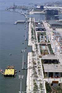 |
| © Parque EXPO'98 S.A. - Abílio Leităo |
- The Panoramic Platform – raised
above the land, to the level of the railway platform, linked up with the Main Route;
- the Central Boulevard
– the main longitudinal axis, linked up to the transversal boulevards, allowing the
urbanistic recovery and redevelopment to spread to the south of the IZ;
- the Diagonal Boulevard
–connected up to the refinery tower and the belvederes at Cabeço das Rolas,
reinforcing the uniqueness of these elements and bringing them into the centre of the
urban stage;
- The Riverfront Walkway
and the Dock – linked up to the riverfront and through the transversal boulevards
with the Central Boulevard and the Panoramic Platform;
- The Riverside Park, connected up to the
riverfront of the River Tagus and the Trancăo, allowing continuity to the north.
- Thinning out of the constructional
occupation from the innermost stretch, next to the railway line – treated there as an
extremely dense urban centre full of buildings with a strong visual impact – and as a
public esplanade and walkway with a low density of buildings and volumetrical sparseness
on the riverfront;
- Diversity of the urban fabric with an
incentive towards quality and singularity in its architecture and towards a balanced
aesthetic and environmental composition of the outdoor spaces;
- Constitution of a continuous green
structure, integrated with the constructed urban structure and the enhancement of the
system of riverside views;
- Safeguarding of the maximum flexibility in
urban management, with respect for the established concepts.
Summarising, the Urbanisation Plan:
- Makes its mark on the land:
- By turning the city to the river and joining
it up to the hinterland – opening a new door to the city;
- With the model of the square mesh;
- With the project of public space;
- By connecting the definitive with the
ephemeral;
- By integrating the memory of the 1998 World
Exposition.
- It generated both singular and diverse
urban and architectural opportunities:
- With architectural landmarks;
- With ephemeral scenarios and urban
installations.
- It guaranteed sustainability by means of:
- Respect for the capacity to support the
natural and urban environment;
- Control of the overall cost and making
possible the maintenance and conservation of the areas;
- The creation of
diversity/singularity/density/multifunctionality generating centrality.
- It made the participation of promoters
possible by means of:
- The interaction of the administration,
technicians and promoters.
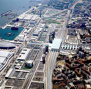
| © Parque
EXPO'98 S.A. - Abílio Leităo |
|